© Moka Studio
Stadteingang Elbbrücken
Diverse neighborhood on former street areas
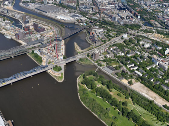
With the Elbbrücken Stadteingang , an urban business and residential district is being created on a former highway cloverleaf. New bridge connections for pedestrians and cyclists provide attractive access. Billhorner Brückenstraße, which runs through the middle of the quarter, is being reinvented as a prestigious main thoroughfare. Characterized by two parks and an overarching green corridor, theElbbrücken Stadteingang offers a high recreational and leisure value.
Current status of development
The development of the Elbbrücken Stadteingangs opens up a unique opportunity for urban renewal. However, extensive infrastructure work is required to prepare for this.
The development plan process is currently underway under the leadership of the Hamburg-Mitte district authority. The aim is to have preliminary approval ready by the end of 2028. On this basis, construction projects can be initiated before the development plan is finalized.
The Billebogen Entwicklungsgesellschaft (BBEG) is moderating the exchange between authorities, service providers and private owners in order to facilitate the complex conversion. Building development is expected to take place primarily in the 2030s.

Development concept
In 2021, the Elbbrücken Stadteingang framework plan was presented, which BBEG had developed together with the Hamburg-Mitte district office and the Ministry of Urban Development and Housing with public participation. In the comprehensive process, architects and open space planners worked together to identify the potential of the area. For the implementation, the offices of gmp Architekten, WES Landschaftsarchitektur, Hager Landschaftsarchitekten (now Uniola) and Argus Stadt und Verkehr developed the plans further.
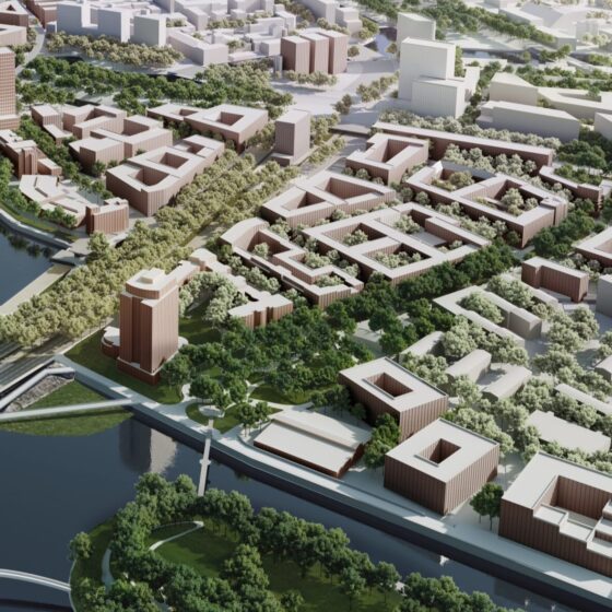
The Elbbrücken Stadteingang framework plan lays the foundations for a modern, urban development of this previously heavily fragmented urban space. It envisages a green belt from the Elbe to the Bille , including a new park. Additional path connections and new access to the water are also included. A wide variety of uses is planned for the districts: modern workplaces in offices, services and urban production as well as places for the creative industries. Residential space can also be created in suitable noise-protected locations.
Urban development
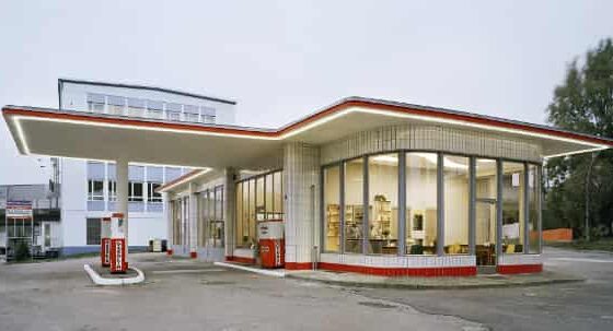
There are already exciting places to discover at the Elbbrücken Stadteingang : a listed petrol station as a classic car meeting place, an expressionist brick ensemble as a location for young gastronomy companies or a high-rise building in the middle of Billhorner Brückenstraße as a creative hot spot. The newly planned urban structures take up these impulses and develop them further. Based on the traditional block development of the old Rothenburgsort, the predominantly five- to six-storey buildings will house small production facilities, art and cultural projects as well as leisure facilities and hotels in addition to office space. In contrast to the other two districts in the Billebogen , housing is also possible at the Stadteingang . However, a prerequisite for the 500 or so residential units on the east side of Billhorner Brückenstraße is that the new buildings are provided with adequate noise protection (which must be created first). A diverse mix of uses is planned for the surrounding area on the first floors, with shopping facilities, restaurants and social infrastructure such as daycare centers, neighborhood meetings and advice centers.
© Moka Studio
More city instead of road
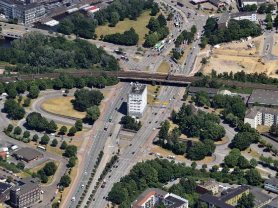
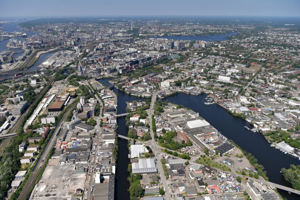
The starting point for the development is the dismantling of a large so-called highway cloverleaf. This was built in the 1960s between Billhorner Brückenstraße and Billhorner Röhrendamm . At that time, the plan was to route both roads through the city as highways.
Fortunately, this plan never became reality. Instead, the existing infrastructure is oversized for actual use. The existing underpass of the Röhrendamm at Billhorner Brückenstraße is still required. However, with new crossings along Billhörner Röhrendamm, the four ramps can be reduced to two. A clever rearrangement of the traffic infrastructure in the district also allows development along the ramps.
This will create a considerable amount of building land in a central location. The Free and Hanseatic City of Hamburg is also planning to transform Billhorner Brückenstraße into a prestigious main thoroughfare. Thanks to the new development along the main road, noise-protected living space can be developed inside the quarters of the Elbbrücken Stadteingangs . This also has the advantage of creating more building land. This enables sustainable internal development instead of taking up new land.
Historical places in a new context
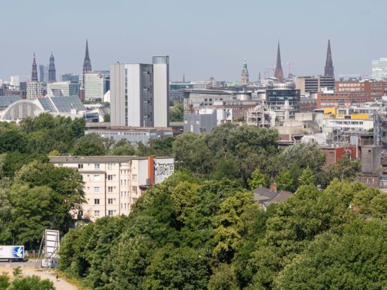
The dismantling of the highway cloverleaf not only gains building land, but also opens up the opportunity for urban renewal. Rothenburgsort had a different character before the Second World War. It was densely built-up and formed the multi-purpose entrance to the center of the Free and Hanseatic City. This character was lost with the destruction of the war.
The new development makes reference to the history and integrates the few existing historical buildings. These include the Brandshof ensemble at Billhafen and the residential buildings on Marckmannstraße and Hardenstrasse.
But the post-war period also remains visible. A single building now standing in the middle of Billhorner Brückenstraße , for example, was originally part of an entire block. Its isolated location will be improved in future by a pedestrian connection to Röhrendamm, but its individual presence in the street space will be retained. The vintage car filling station at the western end of Billhorner Röhrendamm will also be retained. In future, it will form a central point of contact in the newly planned Billepark.
© Moka Studio
Free space
The Elbbrücken Stadteingang is located in the immediate vicinity of the Elbe and the Bille with two spacious parks: the existing Elbpark Entenwerder and the new Billepark. There is also the AlsterElbe Alster and neighborhood squares.
Alster-Bille-Elbe-Grünzug
The Alster-Bille-Elbe-Grünzug links Rothenburgsort with the large parks of the city of Hamburg. In future, an urban park landscape will stretch between Hamburg's three rivers.
In Rothenburgsort , the green corridor runs from the flood basin on the Bille in the north to the Alexandrastieg at Elbpark Entenwerder in the south. Two new connections will make this possible: a bridge will be built over the Bille and a tunnel will be built under the railroad embankment to the south of the Neuer Huckepackbahnhof. Both are designed exclusively for pedestrians and cyclists.
Billhorner Mühlenweg in the Elbbrücken Stadteingang district is being rebuilt for the Elbe Alster. One of the two lanes will become a green space. An attractive town square is being created at the junction with Billhorner Röhrendamm . The potential of this location was discussed with citizens as part of the "Post-Corona-Stadt" project led by the Department for Urban Development and Housing.
In the ensemble of the former spirits monopoly administration, district-related and cultural uses are to further enliven the Elbe Alster. A district center in the Alexandrastieg park area is already being planned.
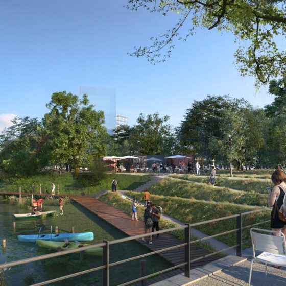
Two large parks: Elbpark Entenwerder and Billepark
Anyone who lives near a green park in a large city will particularly appreciate this. Residents in the newElbbrücken Stadteingang quarter will have two parks to choose from in future.
The Elbpark Entenwerder has been around for over 25 years. It was developed from a former customs station for inland waterway vessels, later simply a parking area. With a view of the Elbbrücken, the growing HafenCity and the industrial backdrop on the southern bank of the Elbe, extensive green and open spaces are opening up directly on the Elbe. Elbpark Entenwerder will be connected to HafenCity by a new bridge for pedestrians and cyclists. The bridge is already under construction and will be completed in mid-2026.
© Moka Studio
© bloomimages
On the western side of the Stadteingang , the Bille flows first into the Oberhafenkanal and then the Elbe. Another green space is being created here: the Billepark, which is being created by linking and redesigning previously little-used, separate green spaces along the Bille .
This park will extend from the mouth of the Bille to the flood basin at the entrance to the Bille basin in the north. It will make the course of the Bille river accessible to the public and create further attractive path connections and new opportunities for use - often right by the water. For example, the functional planning includes a jetty leading from Heidenkampsweg, past Amsinckstraße and the wholesale market, to the Brandshofer Schleuse
At the Elbbrücken Stadteingang , Billepark is characterized by bridges, locks, railroad facilities and existing buildings. A multifaceted design concept creates the conditions for linking the existing locations and integrating new uses. The existing vintage car filling station at the Brandshofer Schleuse will also be retained and the existing water sports use will be integrated in the best possible way.
The realization of Billepark is planned for the early 2030s.
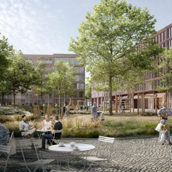
New neighborhood squares
Many areas at the Stadteingang Elbbrücken convey a sense of space - be it the large parks, the main thoroughfare Billhorner Brückenstraße or the water areas. As a counterpoint, dense residential and commercial neighborhoods are emerging, in which more intimate neighborhood squares can be found. Protected from noise, they also offer excellent amenity qualities - for example for commercial areas, outdoor restaurants or playgrounds.
Mobility and logistics
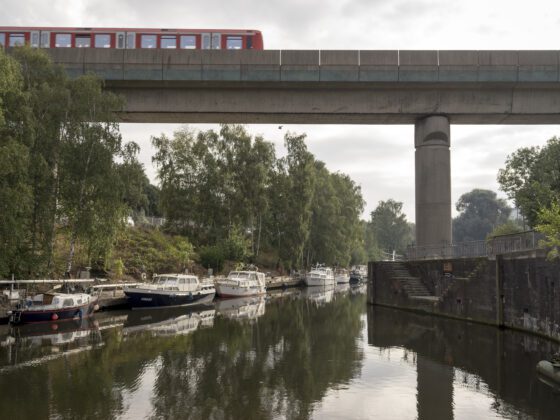
Twelve main traffic axes connect Hamburg's inner city with the outer districts and the neighboring metropolitan region. One of these is the Billhorner Brückenstraße in the center of the Elbbrücken Stadteingangs . As part of the district development and the "Masterplan Magistralen" of the Ministry of Urban Development and Housing, the Billhorner Brückenstraße is being rethought. However, important components of a sustainable mobility space already exist today: the Elbbrücken transport hub with its combined underground and suburban train station is now more accessible for cyclists and pedestrians thanks to a new bridge.
© bloomimages
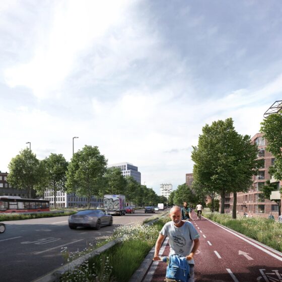
From an urban highway to a main thoroughfare
Over the water, under the railroad, along commercial and multi-storey residential buildings - on its way from the city center towards the port, the Billhorner Brückenstraße hardly leaves out any urban space. It is clear that the section between Amsinckstraße and Elbbrücken in the area of the Neuer Huckepackbahnhof and Stadteingang Elbbrücken districts will continue to be dominated by car traffic. Nevertheless, the mobility turnaround will also be felt here in the future. In the area of the oversized freeway cloverleaf, which will make way for the district development, traffic will be reorganized in favour of the district. Car and bus traffic will be reorganized. Parking spaces will be optimized and partly relocated to underground or neighborhood garages. A large part of the current street areas will be reused in the future - whether for buildings and neighborhood squares or future green spaces, or for a network of paths that improves mobility for pedestrians and cyclists.
© Moka Studio
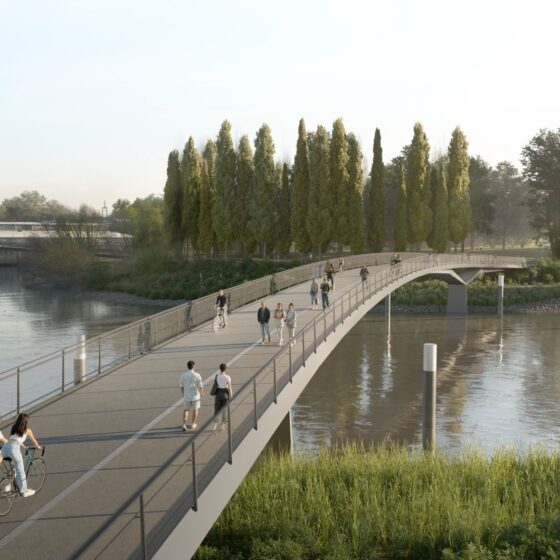
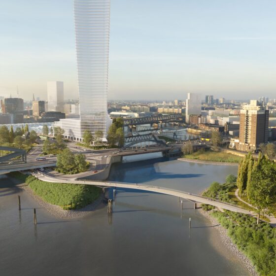
New bridges to the Elbbrücken underground and S-Bahn station
A new subway station was opened at Elbbrücken in 2018 and a new S-Bahn stop was added at the end of 2019: a highly attractive public transport service has been available at this transport hub for more than five years. The Elbbrücken Stadteingang and the entire Rothenburgsort district are already linked to the Elbbrücken station via bus routes. In future, there will be two direct connections for pedestrians and cyclists: The Entenwerder bridge leads from the park of the same name across the mouth of the Oberhafen Canal into HafenCity. With a sweeping and dynamic gesture, the 138-metre-long and approximately 7-metre-wide bridge spans the water on two supports, between which there is a free span of 75 meters. In future, a two-way cycle path and a footpath will run across the bridge. Recreation areas are planned at the bridgeheads. The schlaich bergermann partner team and gmp Architekten von Gerkan, Marg und Partner won the competition to design the bridge in 2020. Construction has already begun and the opening is planned for 2026.
A second bridge over the Billhafen links the future Billepark and the area around the Brandshof with the Elbbrücken underground and S-Bahn station.
More information
Real estate
Billebogen Entwicklungsgesellschaft (BBEG), a subsidiary of HafenCity Hamburg GmbH, has more than 20 years of experience in urban development. It offers attractive properties for investors and property developers in new, vibrant urban spaces with a focus on commercial development.
Participation
On behalf of the Free and Hanseatic City, Billebogen Entwicklungsgesellschaft (BBEG) is also responsible for communication on neighborhood development. Current issues are communicated transparently and suggestions and needs of the neighborhood can be brought forward in various formats. There are numerous opportunities for this.
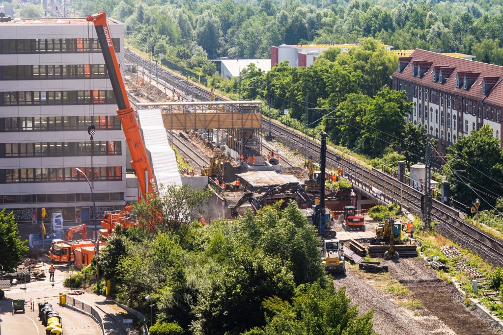
Construction activities
The Free and Hanseatic City of Hamburg is expected to invest around 250 million euros in the infrastructure of the new neighborhoods and the existing Rothenburgsort district via the Billebogen Entwicklungsgesellschaft (BBEG). Here you will find an overview of construction measures in the neighborhood.